TUFLOW has a global reputation for its unsurpassed 1D/2D dynamic linking, outstanding workflow efficiency, accuracy and speed in simulating floods, tides and integrated urban catchment systems. The TUFLOW 1D solver that links to the 2D grid or quadtree mesh is one of the most sophisticated available.
Our latest 2D grid based solver, TUFLOW HPC (Heavily Parallelised Compute), builds upon the hallmarks of TUFLOW Classic's industry leading strengths and accuracy. HPC incorporates finite volume TVD shock capturing, adaptive timestepping stability, and GPU acceleration that achieves 10 to 400 times shorter simulation times than TUFLOW Classic (which was already established as one of the world's fastest and most accurate CPU 2D solvers).
The accuracy, stability, speed, quadtree mesh structure and sub-grid sampling (SGS) make TUFLOW HPC the world's most powerful 1D/2D hydrodynamic computational engine.

TUFLOW’s 1D engine (ESTRY) is feature filled. It caters for 1D open channels, culverts, underground pipe networks, pumps, weirs, bridges and a wide array of operational structures. TUFLOW's 1D/2D linking is world leading in terms of its stability and heritage (dating back to 1991). 1D/2D integrated urban catchment modelling is one of TUFLOW's most popular applications due to:
TUFLOW HPC's speed using GPU hardware and efficient memory treatment. TUFLOW can happily accommodate over 10 million 2D cells on inexpensive GPU cards.
ESTRY's detailed underground pipe network hydraulic computations fully accommodates for pressurised or non-pressurised flows. Hydraulic losses throughout the network are calculated dynamically every computational timestep based on the hydraulic conditions, junction/manhole geometry, and the pipe inverts and angles of approach/departure.

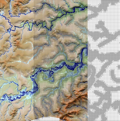
Quadtree allows fixed grid meshes to vary in cell size, so enables higher resolutions where more refined hydraulic calculations are needed, and lower resolutions where there is little variation in topography (e.g. floodplains). Divide a cell into four cells, then further divide those into four, and so on.
Quadtree has multiple benefits. Intelligent quadtree implementation reduces the model cell count to achieve equivalent solution accuracy compared to a single cell resolution model. This translates to smaller memory footprints and faster simulation speeds.
The beauty of Quadtree is that the final mesh can be constructed in minutes as opposed to hours/days for a well-designed flexible mesh. And combining quadtree with sub-grid sampling (SGS) means flexible mesh quality results can be achieved at any grid orientation and much faster run times.

Accuracy underpins TUFLOW's development. TUFLOW has been continuously benchmarked to theory and flume model measurements, and calibrated to real historic events on thousands of occasions over 30+ years of innovation, research and development. Why can TUFLOW be relied on more than other software? Because TUFLOW uses:

Result convergence refers to the tendency for model results to trend towards a common answer as model inputs and parameter values are refined (i.e. reducing timestep or cell size). TUFLOW's hydraulic solvers demonstrate excellent result convergence. They outperform other software in timestep and cell size convergence tests. This means, compared to other competing 2D hydraulic modelling software, coarser resolution (i.e. faster) models can be developed using TUFLOW without loss of accuracy.
A key strength of TUFLOW's design is the cell size independence of spatial inputs. The cell resolution in TUFLOW Classic/HPC model can be updated by changing a single parameter value. TUFLOW then automatically resamples all supporting GIS data at the new resolution, with no need for user rework.

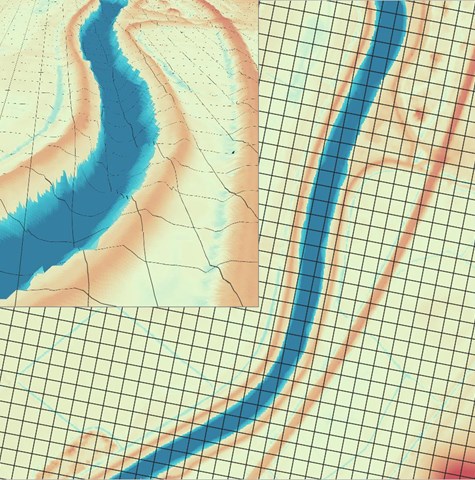
TUFLOW HPC, with its powerful Sub-Grid Sampling feature, produces accurate results for flow along narrow channels at any orientation of the structured mesh. This means there is no need to use a flexible (unstructured) mesh or alternatively an excessively high fixed grid (structured mesh) resolution to model these flow paths. This feature of TUFLOW significantly reduces model setup effort, project time and cost. Also, the ability to use a coarser resolution compared to traditional fixed grid solutions substantially reduces simulation run times.

TUFLOW has unrivaled Geographic Information System (GIS) software integration. Models can be developed using ArcGIS, QGIS or MapInfo. Simulation results are written directly to free open formats also read by these GIS software. As a result of this GIS development environment configuration TUFLOW licences are not needed to create model inputs or view outputs. Licences are only needed to run simulations.
For those who prefer building models and viewing results in a Graphical User Interface (GUI), a variety of third party GUI's are also available: 12D, Flood Modeller, SMS, XP-SWMM.
