11 December 2020
Sustainable Drainage Systems (SuDS) has continued to gain traction in the UK as developers and local councils look to integrate urban infrastructure and surface water management. Previous surface water and drainage management practices have treated runoff as a liability needing to be conveyed as quickly as possible. This resulted in Urban Stream Syndrome, where downstream water bodies show an increased concentration of nutrients, visible pollution and erosion. Concerted efforts to view runoff as a resource and potential benefit to the community has led to similar initiatives around the world through Low-Impact Development (LID) in the Unites States, Water Sensitive Urban Design (WSUD) in Australia and Nature-based Solutions in the EU.
SuDS features are being developed throughout the UK and a good example can be found in the award-winning Grey to Green Phase 1 project in Sheffield. In 2018, Sheffield City Council received the CIRIA Overall SuDS award for the first stage of their development, Grey to Green. The urban transformation revitalised the previously tired and impervious highway junction in the heart of Sheffield.
As part of the SuDS design, vegetated swale cells were connected in series and linked by weirs. The swales sit adjacent to Bridge Street, with sheet flow from the surrounding road and foot traffic areas being conveyed into the channel to be treated and attenuated by the vegetation.
The Grey to Green Phase 1 site in Sheffield was chosen to showcase the capability of 12d Model to interface with TUFLOW for designing SuDS, assessing their potential benefit and to demonstrate the visualisation of results. TUFLOW/12D were not involved in the original design and we have replicated the schematisation to showcase the software functionality. All the engineering features and rainfall used as part of this case study are approximations and this analysis makes no attempt to measure the performance of the Sheffield SuDS design. The following features of each software package have been incorporated into the SuDS design:
3-dimensional (3D) road and swale design;
A TUFLOW Quadtree mesh;
Sub-Grid Sampling for inclusion of small topographic features;
Realistic urban materials and furniture; and
Video animation and perspective visualisation of the results
Figure 1: Animation
12d Model is a comprehensive data terrain modelling, surveying and civil engineering design software package that has integrated the full suite of numerical modelling capabilities of TUFLOW. LiDAR data from DEFRA was imported into 12d Model and the roads, pedestrian areas and vegetated swales were recreated to build the BIM model with digital terrain. Once the design was complete, a TUFLOW model was created with 12d Model’s TCF editor using a rainfall on mesh analysis. One of the many benefits of using a multi-disciplinary software such as 12d Model is the ability to automate design changes and manage all data in a single point of truth. Textures can also be applied to surfaces giving a realistic appearance, combined with providing unparalleled design clarity through synchronised plan, section and perspective view analysis. Figure 2 highlights the real holistic benefit from designers/modellers through to the client and the general public. At any stage of development and angle you can see how your design performs hydraulically in a realistic environment that can be used as part of client engagement or public consultation.
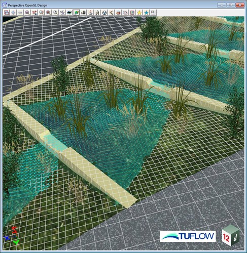
Figure 2: Swale design with TUFLOW results, urban furniture and surface texturing.
The latest TUFLOW 2020 build feature Quadtree mesh refinement, was applied to take advantage of nested higher resolution mesh cells. This was particularly focused around the detailed weirs which have been constructed to separate the treatment areas. The setup of a Quadtree mesh is much simpler and faster than the TUFLOW Classic method of stitching multiple domains together and removes the headache of managing numerous control files. Figure 3 shows the nested capability around features of importance within a SuDS design. Linking your hydraulic model around areas of interest within your civil engineering design allows for a more efficient setup and computation. Further details concerning the creation of a Quadtree model can be found at the bottom of this article.
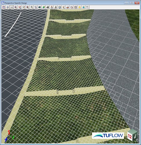
Figure 3: Perspective view of the SuDS feature overlaid with the QPC mesh.
To further enhance the estimation of cell volume for micro-topographic features and cells that are only partially wet, the new Sub-Grid Sampling (SGS) processing was also utilised. The traditional approach used to represent cell volume is as a square bucket with one elevation (the ZC elevation point). SGS on the other hand samples the underlying terrain to calculate a non-linear cell volume with elevation relationship (as well as flow width/area versus elevation relationships for each cell face). SGS has been shown to be amazingly effective in removing “choking” effects from irregular velocities/streamlines due to “saw-tooth” effects along deep sided channels and artificial constrictions that occurs from using a single elevation per cell. Further research can be found at TUFLOW Insights. For the purpose of this showcase, correct conveyance through the weirs and along the swales could only be achieved for any orientation of the 2D grid by using the SGS feature.
As was the design intent, the flooding mechanisms within the TUFLOW simulation predicts surface water from the roadway and surrounding areas sheeting off into the linear swale. An animation of these results shows low level attenuation occurring in each SuDS swale before overtopping the weirs and flowing into the swale downstream. Because the terrain and two-dimensional (2D) hydraulics were both designed within 12d Model we were able to take advantage of the many post-simulation visualisation capabilities. Perspective view animations, landscape features, vegetation and much more can be incorporated to bring your designs to life.
Figure 4: Long section animation through the SuDS feature
12d Model and TUFLOW provides an excellent way of integrating what were historically siloed areas of responsibility for civil designers, flood modellers and client liaison. This example showcases how 12d Model - TUFLOW can help customers overcome their problems in design and flooding projects by providing the connectivity from concept through to construction. If you wish to further engage with stakeholders and streamline your design process, 12d Model and TUFLOW will provide the added value you have been looking for.
Please get in touch with the TUFLOW team to discuss how these packages can assist with your next civil engineering and SuDS venture.
Susdrain SuDS Award winner 2018 – Sheffield City Council
TUFLOW - Info
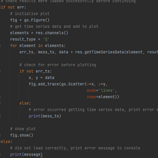
TUFLOW's PyTUFLOW toolbox provides an interface into the TUFLOW results file which allow the user to quickly and consistently process model outputs. An example is provided which integrates PyTUFLOW with the Plotly graphing library to produce interactive plots comparing modelled outputs with observed flow measurements.
TUFLOW - Info
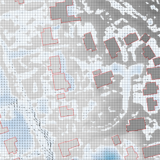
Sub-Grid Sampling opens up the door to offer major benefits to Urban Surface Water Modelling, particularly with regards the simulation of property flood depths, an important metric for flood risk management
TUFLOW - Info
To solve environmental problems in our rivers, lakes, estuaries and coastal waters, hydrodynamic models rely on a range of boundary condition forcings. For a complex model, there may be hundreds of necessary boundary conditions, each requiring input data for multiple parameters.
TUFLOW - Info
The Pix Brook Flood Study is a multi-stakeholder options and feasibility investigation needing an integrated catchment wide model. TUFLOW was chosen due to its ability to represent surface water, fluvial and pipe networks within the one modelling software.